


 pro-iBiosphere wiki platform
 RSS news
Huge data encompassed into a unique georeferenced macrobenthic assemblages database
A new peer-reviewed data paper offers a comprehensive, open-access collection of georeferenced biological information about the Antarctic macrobenthic communities. The term macrobenthic refers to the visible-for-the-eye organisms that live near or on the sea bottom such as echinoderms, sponges, ascidians, crustaceans. The paper will help in coordinating biodiversity research and conservation activities on species living near the ocean bottom of the Antarctic.
The data paper "Antarctic macrobenthic communities: A compilation of circumpolar information", published in the open access journal Nature Conservation, describes data from approximately 90 different expeditions in the region since 1956 that have now been made openly available under a CC-By license. The paper provides unique georeferenced biological basic information for the planning of future coordinated research activities, for example those under the umbrella of the biology program Antarctic Thresholds – Ecosystem Resilience and Adaptation (AnT-ERA) of the Scientific Committee on Antarctic Research (SCAR). The information collected could be also beneficial for current conservation priorities such as the planning of Marine Protected Areas (MPAs) by the Commission for the Conservation of Antarctic Marine Living Resources (CCAMLR).
The expeditions were organised by several famous explorers of the Antarctic. The area covered by the paper consists of almost the entire Southern Ocean, including sites covered by a single ice-shelf. The vast majority of information is from shelf areas around the continent at water depth shallower than 800m. The information from the different sources is then attributed to the classified macrobenthic assemblages. The results are made publicly available via the "Antarctic Biodiversity Facility" (data.biodiversity.aq).
A specific feature of this paper is that the manuscript was automatically generated from the Integrated Publishing Toolkit of the Antarctic Node of the Global Biodiversity Information Facility (AntaBIF IPT) and then submitted to the journal Nature Conservation through a novel workflow developed by GBIF and Pensoft Publishers. (see previous press release). Data are made freely available through the AntaBIF IPT, and sea-bed images of 214 localities through the data repository for geoscience and environmental data, PANGAEA- Data Publisher for Earth and Environmental Science (sample: http://doi.pangaea.de/10.1594/PANGAEA.198682).
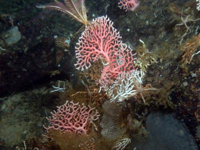 This picture shows the hydrocorals also known as sea fan. (@Julian Gutt, Alfred Wegener Institute)

The European Union funded EU BON "Building the European Biodiversity Observation Network" project now holds its official Kick-off Meeting, taking place from 13 to 15 February 2013 in Berlin. An International Symposium "Nature and Governance – Biodiversity Data, Science, and the Policy Interface" precedes the kick-off (11-12 February 2013), to discuss the current landscape of monitoring and integration of biodiversity data, and stress on the relevance of EU BON on both European and global scales.
The EU BON project will be working towards advancement and development of the technological platform for GEO BON (Group on Earth Observations Biodiversity Observation Network), which operates and systemizes biodiversity data on a global scale.
Launched in 2005, the Group on Earth Observations, GEO, is a response to the need to address issues of biodiversity preservation as well as eight other societal benefit areas: agriculture, climate, disasters, ecosystems, energy, health, water and weather. The GEO BON venture was established to coordinate the provision of sustained, cross-cutting, integrated and accessible earth observation data and information.
The aim of GEO BON is to build a monitoring network that presents a full picture of what is happening to biological diversity worldwide. The system will use masses of biological information with data and forecasts on climate change, pollution, land use, biological invasions and other threats to biodiversity. Currently, the lack of comprehensive information about the world's biological resources continues to undermine the efforts of policymakers and managers to set priorities, elaborate strategies and assess the effectiveness of their actions.
EU BON project offers an innovative approach in terms of integration of biodiversity information system from on-ground to remote sensing data, for addressing policy and information needs in a timely and customized way. The project will reassure integration between social networks of science and policy and technological networks of interoperating IT infrastructures. EU BON's aims to facilitate GEO BON's work towards the creation of global biodiversity data network through contributing to the overall European capacities and infrastructures for environmental information management.
###
All interested parties are most welcome to attend the symposium or to follow it on Twitter, Facebook, or Google+.
Additional information
EU BON (2012) stands for "Building the European Biodiversity Observation Network" and is an European research project, financed by the 7th EU framework programme for research and development (FP7). EU BON seeks ways to better integrate biodiversity information and implement into policy and decision-making of biodiversity monitoring and management in the EU.
GEO BON stands for "Group on Earth Observations Biodiversity Observation Network". It coordinates activities relating to the Societal Benefit Area (SBA) on Biodiversity of the Global Earth Observation System of Systems (GEOSS). Some 100 governmental, inter-governmental and non-governmental organisations are collaborating through GEO BON to organise and improve terrestrial, freshwater and marine biodiversity observations globally and make their biodiversity data, information and forecasts more readily accessible to policymakers, managers, experts and other users. Moreover, GEO BON has been recognized by the Parties to the Convention on Biological Diversity. More information at: http://www.earthobservations.org/geobon.shtml.
 GEO BON Logo
EU BON (2012) stands for "Building the European Biodiversity Observation Network". This European research project, financed by the 7th EU framework programme for research and development (FP7), started activities on the 1st of December 2012 and will continue for 4.5 years. EU BON seeks ways to better integrate biodiversity information and implement into policy and decision-making of biodiversity monitoring and management in the EU. The aim of EU BON is to build a substantial part and contribute to the Group on Earth Observation's Biodiversity Observation Network (GEO BON)*, through an innovative approach of integration of biodiversity information systems. The project, built as an answer to the need of a new integrated biodiversity data, will facilitate access to this knowledge and will effectively improve the work in the field of biodiversity observation in general.
The EU BON International Symposium "Nature and Governance – Biodiversity Data, Science, and the Policy Interface", took place in Berlin from 11 to 12 February 2013. The symposium, hosted by the Museum für Naturkunde Berlin, brought together high-ranking speakers and guests from across the world to talk and discuss the different aspects of the EU BON Project. The symposium aimed at clarifying and popularizing EU BON's objectives prior to the official EU BON Kick-off Meeting. Main issues covered were the future of biodiversity information, challenges in front of new data policies, new approaches in collecting information, and ways to engage the public in biodiversity monitoring and assessments, a.o.
For more information on the EU BON project please visit Twitter, Facebook, or Google+.
* Launched in 2005, the Group on Earth Observations, GEO, is a response to the need to address issues of biodiversity preservation as well as eight other societal benefit areas: agriculture, climate, disasters, ecosystems, energy, health, water and weather. The GEO BON venture was established to coordinate the provision of sustained, cross-cutting, integrated and accessible earth observation data and information.
GEO BON stands for "Group on Earth Observations Biodiversity Observation Network". It coordinates activities relating to the Societal Benefit Area (SBA) on Biodiversity of the Global Earth Observation System of Systems (GEOSS). Some 100 governmental, inter-governmental and non-governmental organisations are collaborating through GEO BON to organise and improve terrestrial, freshwater and marine biodiversity observations globally and make their biodiversity data, information and forecasts more readily accessible to policymakers, managers, experts and other users. Moreover, GEO BON has been recognized by the Parties to the Convention on Biological Diversity. More information at: http://www.earthobservations.org/geobon.shtml.
The aim of GEO BON is to build a monitoring network that presents a full picture of what is happening to biological diversity worldwide. The system will use masses of biological information with data and forecasts on climate change, pollution, land use, biological invasions and other threats to biodiversity. Currently, the lack of comprehensive information about the world's biological resources continues to undermine the efforts of policymakers and managers to set priorities, elaborate strategies and assess the effectiveness of their actions.

Taxonomy – the discipline that defines and names groups of organisms – is a field of science that still employs many of the methods used during the beginnings of the discipline in the 18th century. Despite the increasing use of molecular information to delineate new species, the study of the morphology of specimens remains one of the major tasks of taxonomists. These studies often require first-hand examination of the reference specimens (so-called type material) deposited at museum collections around the globe - a time-consuming and laborious task.
To facilitate this procedure, a group of researchers from the Hellenic Centre for Marine Research (HCMR) are exploring the possibilities offered by 3D digital imaging. In a recent article published in the open-access journal ZooKeys, the researchers use X-ray computed tomography to create digital, three-dimensional representations of tiny animals, displaying both internal and external characteristics of the specimens at a detail level similar to that of the microscope.
To demonstrate their method, the researchers imaged a number of polychaete species (marine bristle-worms)—the choice of this group being obvious to Sarah Faulwetter, the leading author, because "despite being ecologically very important, these animals exhibit a fascinating diversity of forms and tissue types, allowing to test the methodology across a range of samples with different characteristics".
The resulting interactive 3D models allow any researcher to virtually rotate, magnify or even dissect the specimen and thus extracting new scientific information, whereas the structure and genetic material of the analysed specimen are kept intact for future studies.
The team stress the importance of 3D imaging methods for taxonomy on its way into the twenty-first century: "Our vision for the future is to provide a digital representation of each museum specimen, simultaneously accessible via the internet by researchers and nature enthusiasts worldwide," says the team leader, Dr Christos Arvanitidis from HCMR.
The instant accessibility of specimens will speed up the creation and dissemination of knowledge. As the authors point out, "human efforts, combined with novel technologies, will help taxonomy to turn into a cyberscience whose discoveries might rival those made during the great naturalist era of the nineteenth century."
See also the playlist in the Pensoft video channel at http://www.youtube.com/playlist?list=PLrYfgSbGP4qRsKnc-47wkxgz6ww1HMHox
###
The study was supported by the European Union projects MARBIGEN (FP7-REGPOT-2010-1) and ViBRANT (RI-261532)
Original Source:
Faulwetter S, Vasileiadou A, Kouratoras M, Dailianis T, Arvanitidis C (2013) Micro-computed tomography: Introducing new dimensions to taxonomy. ZooKeys 263: 1-45. doi: 10.3897/zookeys.263.4261
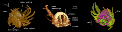 This shows virtual dissection images of a specimen of a marine bristle-worm (Syllis gracilis) acquired through computed tomography and showing external and internal anatomical features
A second article acknowledging results accomplished within the EC FP7 project pro-iBiosphere has now been published. The paper titled: An appraisal of megascience platforms for biodiversity information, reflects the aspects of processing and provision of biological research data on various online platforms, in an environment where data driven approaches, are increasingly important.
Pro-iBiosphere is recognized as a coordination project that provides global generic organismic knowledge and a platform that brings the traditional Flora and Fauna editorial efforts into the digital world.
The full contents of the article are available online at: http://dx.doi.org/10.3897/mycokeys.5.4302>
PDF version is also available here.
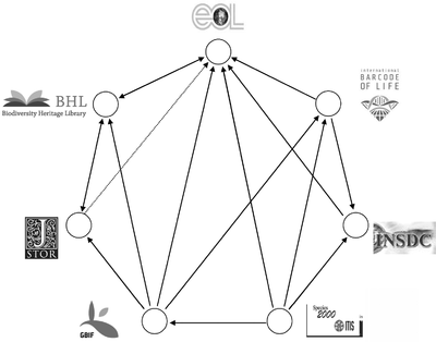 Biodiversity megascience platforms – cross-linkages and data exchange

The EU BON project which is coordinated by the Museum für Naturkunde in Berlin/Germany has started on 1 December and will continue for 4.5 years. The EU BON Kickoff Meeting will be held in Berlin from 13 to 15 February 2013.
With respect to EU BON’s objectives the International Symposium "Nature and Governance – Biodiversity Data, Science, and the Policy Interface" will be held prior to the EU BON Kickoff Meeting from 11 to 12 February in Berlin with high-ranking speakers. You are most welcome to attend the Symposium.
 EU BON logo

